

ARCHITECTURE / 01X / SELECTED PROJECT

NEW ARK

Manchester, UK | 2025–2026 | Individual Work | Academic Study

+ Modelling:
+ Interaction:
+ Visualisation:
+ Post-production:
OVERVIEW

Computational Design for a Climate-Resilient Future City

New Ark explores how computational design methodologies can support climate-resilient urban design under climate change. Located in Trafford Park, Greater Manchester, the project proposes a residential-led mixed-use district for 2030 and beyond, responding to future risks of Extreme Heat, Extreme Rainfall, and prolonged Winter Cold.

Using parametric modelling, iterative urban testing, and scenario-based evaluation, the project develops adaptive strategies across urban planning, landscape systems, and architectural form.

The project aims to improve Trafford Park’s adaptive capacity while creating a new urban identity connected to the wider city. By reducing heat exposure, managing rainfall and flood risk, softening winter climate impacts, and supporting more comfortable public spaces, New Ark proposes a more sustainable, resilient, and liveable model for future urban communities.

01

OVERVIEW

15 WORKS
OVERVIEW / 01

Site Context

Trafford Park is located in the Metropolitan Borough of Trafford, Greater Manchester, about 5.5 km south-west of Manchester city centre. Bounded by the Manchester Ship Canal and the Bridgewater Canal, it forms an almost island-like industrial estate covering around 12 km². It is widely recognised as the world’s first planned industrial estate, with key landmarks such as Old Trafford Stadium and the Trafford Centre located nearby.
OVERVIEW / 02

Key Design Challenges

Based on collected site data and contextual evidence, this project defines its main challenge as responding to the future impacts of climate change on the site. It aims to improve resilience under three key climate challenges: Extreme Heat, Extreme Rainfall, Winter Cold. Rather than treating these issues separately, the project develops an urban design response that considers their combined effects and explores integrated solutions to strengthen long-term resilience and adaptive capacity. H: Strongly summer-peaking seasonal and is trending towards more frequent, longer-lasting, and more intense heatwaves. R: Seasonally structured risk, with wetter winters on average and an increasing importance of high-intensity downpours. C: A long-standing baseline seasonal condition in the UK, which may become milder on average but still includes intermittent cold spells.

OVERVIEW / 03

Projected Climate Risk Patterns

Using the Generic Foresight Process Framework and the RCP8.5 scenario, this diagram projects future climate risks for the site. It shows how extreme heat, extreme rainfall, and winter cold may appear as seasonal patterns, triggering different levels of risk across the year. These risks are likely to affect public comfort, health, resilience, and daily urban life, with their severity increasing over time.

OVERVIEW / 04

Climate Risk Mapping

The mapping shows the key destinations and climate risk zones across Trafford Park. High heat-risk areas cover much of the site, canal-edge zones are exposed to fluvial flood risk, and surface water flood hotspots are scattered across the area. Daily activity is mainly concentrated around the Trafford Centre and Old Trafford Stadium.

OVERVIEW / 06

Computational Iteration

Based on the allocation rules and design typologies, the project generates a large number of computational iterations to test different spatial arrangements across the site. Each iteration explores how typologies can be distributed, combined, and adjusted under the same design logic. This page presents 36 selected iteration results, showing the range of possible outcomes produced through the workflow. These results are then classified, tested, and calculated through the evaluation method, before entering the screening stage for further comparison and selection. This page presents selected iteration results and their converted scores. The following score titles are abbreviated as: HS = Extreme Heat Score, RS = Extreme Rain Score, CS = Winter Cold Score, US = Urban Function Score, OS = Overall Score

OVERVIEW / 07

Scoring Framework

The scoring framework converts urban function and climate performance results into comparable scores. This page uses the final selected result as a demonstration case to show how programme balance, extreme rainfall, extreme heat, and winter cold performance are evaluated and combined into an overall score for comparison and final selection.

OVERVIEW / 08

Interactive Climate Design Application

This application presents and compares selected New Ark design iterations through an interactive visual interface. It is designed for students, designers, tutors, and stakeholders involved in climate-resilient urban design. Users can switch between ranking results, 2D and 3D views, and different climate modes, including heat, rain, and cold. The application helps users understand complex climate data, compare design performance, and explore how computational design can support future urban resilience.

APPLICATION 操作演示视频

OPEN VIDEO ↗
OVERVIEW / 09

Urban-scale Climate Strategy Upgrade

The selected iteration shows weak winter performance and limited rainwater management capacity. Further analysis identifies gusts and high wind speed as key causes of winter discomfort, while flood resilience needs to address both RoFSW and RoFRS risks. Based on the original result, the design is upgraded through urban wind-control strategies and flood-management systems for surface water and canal-edge flooding.

OVERVIEW

Urban Masterplan

OVERVIEW / 11

Urban Living

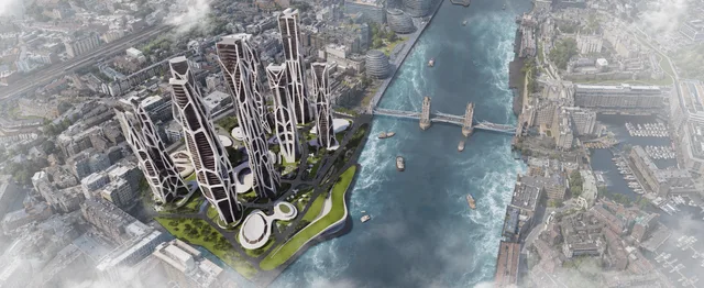
The Urban Living district forms the main residential area within the masterplan, combining different housing typologies to create a varied and connected living environment. Twist Towers act as vertical landmarks, while Stacked Residential buildings provide higher-density housing and Connected Clusters create a gradual transition towards lower-rise areas. Rather than working as isolated buildings, these typologies are linked through shared terraces, roof gardens, balconies and landscaped public spaces. Together, they create a sequence of private, communal and public spaces across different levels. Their form and arrangement also respond to changing climate conditions. Building orientation, spacing, façade depth and planted terraces help provide summer shading, maintain winter solar access, reduce wind exposure and manage rainfall. The following drawings show how these principles are developed through the different residential typologies.

OVERVIEW / 12

Urban Working

Urban Working brings together office, commercial and shared facilities to form the main employment and activity zone of NEW ARK. Its typologies range from larger office clusters to twin-block workplaces and lower commercial buildings, creating different scales of working space and a more active urban edge. The area is organised around movement and exchange. Linked office floors, shared circulation spaces and accessible ground-level uses encourage interaction between workers, visitors and surrounding public areas, while commercial functions help extend activity beyond normal office hours. Environmental performance is integrated into the architecture through layered façades, planted roofs and controlled building forms. These elements help reduce overheating and glare, moderate local wind conditions, and guide rainfall towards landscape and drainage systems. Together, the typologies create a more adaptable working district that combines workplace efficiency, public activity and climate-responsive design.

OVERVIEW

New Horizon in the Rain

OVERVIEW

Crossing the Winter Wetland

OVERVIEW

Shaded Mobility Corridor

02

DESIGN PROCESS

04 WORKS
DESIGN PROCESS / 01

Computational Allocation Method

The allocation rules are developed by linking the Pattern Dictionary with site-specific functional analysis. The Pattern Dictionary first extracts climate-resilient spatial patterns from urban case studies and recombines them into a set of design languages. These design languages are then adapted to the site’s functional needs, climate risks, access routes, and spatial hierarchy, forming typologies that can be used within the computational design process. In the iteration process, these typologies become allocation rules, guiding where each type can be placed and how different urban functions are distributed across the site.

DESIGN PROCESS

Area Zoning

03

ALGORITHM

06 WORKS
ALGORITHM / 02

Computational Iteration

Based on the allocation rules and design typologies, the project generates a large number of computational iterations to test different spatial arrangements across the site. Each iteration explores how typologies can be distributed, combined, and adjusted under the same design logic. This page presents 36 selected iteration results, showing the range of possible outcomes produced through the workflow. These results are then classified, tested, and calculated through the evaluation method, before entering the screening stage for further comparison and selection. This page presents selected iteration results and their converted scores. The following score titles are abbreviated as: HS = Extreme Heat Score, RS = Extreme Rain Score, CS = Winter Cold Score, US = Urban Function Score, OS = Overall Score

ALGORITHM / 03

Surface Water Evaluation Algorithm Development

As there is no single standard method that can directly evaluate the rainwater management capacity of every generated urban iteration, this project develops a simplified computational evaluation system. The method is based on a general understanding of rainfall behaviour. This system allows each iteration to be tested as it is generated, so that its surface water handling capacity can be compared within the design workflow. Two site-specific future rainfall conditions are defined for evaluation: a normal scenario and an extreme scenario. These scenarios are used to assess how different urban layouts perform under the projected rainfall pressures of the site.

ALGORITHM / 04

Outdoor Comfort Evaluation Algorithm Development

As there is no single existing method that can fully meet the needs of evaluating outdoor comfort across every generated urban iteration, this project develops an adapted computational evaluation system. The method is based on Ladybug’s UTCI calculation, but is further modified and upgraded to fit the project’s climate scenarios, spatial scale, and iterative design workflow. This system allows each iteration to be tested for outdoor comfort performance as it is generated. By comparing comfort conditions under different future climate pressures, the algorithm helps assess how different urban forms, open spaces, shading conditions, and landscape strategies can improve the quality of public space. This algorithm is based on the Universal Thermal Climate Index (UTCI), which measures outdoor thermal comfort through equivalent temperature. It uses future weather data generated from the Manchester EPW file with the Future Weather Generator, based on RCP8.5 2050 and RCP8.5 2080 scenarios. UTCI is driven by four key inputs: 1) Mean Radiant Temperature (MRT) 2) Air Temperature 3) Wind Speed (affected by context) 4) Humidity While this project further adjusts wind speed, surface conditions, sampling periods, and site context for iteration-based evaluation.

ALGORITHM / 05

Scoring Framework

The scoring framework converts urban function and climate performance results into comparable scores. This page uses the final selected result as a demonstration case to show how programme balance, extreme rainfall, extreme heat, and winter cold performance are evaluated and combined into an overall score for comparison and final selection.

ALGORITHM / 06

Interactive Climate Design Application

This application presents and compares selected New Ark design iterations through an interactive visual interface. It is designed for students, designers, tutors, and stakeholders involved in climate-resilient urban design. Users can switch between ranking results, 2D and 3D views, and different climate modes, including heat, rain, and cold. The application helps users understand complex climate data, compare design performance, and explore how computational design can support future urban resilience.

APPLICATION 操作演示视频

OPEN VIDEO ↗
04

DRAWINGS

01 WORKS
DRAWINGS / 01

Urban-scale Climate Strategy Upgrade

The selected iteration shows weak winter performance and limited rainwater management capacity. Further analysis identifies gusts and high wind speed as key causes of winter discomfort, while flood resilience needs to address both RoFSW and RoFRS risks. Based on the original result, the design is upgraded through urban wind-control strategies and flood-management systems for surface water and canal-edge flooding.

05

TYPOLOGIES

06 WORKS
TYPOLOGY / 01

Twist Tower

POSITION & ROLE

Four Twist Towers are placed across the site. One tower (the example) stands near the Community Heart as a landmark building, combining residential use with hotel accommodation for visitors. The other three towers form a residential cluster, creating a vertical sub-community within the wider masterplan.

FUNCTION VALUE

This typology provides a strong visual identity while also delivering a high amount of housing within a compact footprint.

CLIMATE RESPONSE

Its rotated form and secondary façade are used as climate-responsive design tools. The twisting massing can help disrupt direct wind flow and reduce wind pressure around the tower, while the façade and roof layers can slow down rainwater movement and support partial rainwater interception. Twisting is recognised as one of the aerodynamic modifications used to reduce wind effects on tall buildings, while green roof systems can intercept and retain rainfall, reduce runoff volume, and attenuate peak flows.

Deflect downwash
Shape terrain
Round corners
Smooth transition
Filter wind
Guide runoff
Blue-green roof

PLANS & SECTION

Click to inspect drawings ↗
TYPOLOGY / 02

Stacked Residential

POSITION & ROLE

The Stacked Residential typology acts as the main high-rise housing type within the site. It is mainly placed along the central residential belt, keeping distance from the surrounding industrial context while allowing residents to gain wider views towards the canal, landscape, and city edge.

FUNCTION VALUE

This typology provides a large amount of housing within a compact footprint. The stacked form creates shared sky gardens and semi-private outdoor terraces, supporting planting, daily rest, social activity, and access to green space above ground level.

CLIMATE RESPONSE

The stacked and staggered form helps control seasonal solar access. It can shade high-angle summer sun while allowing lower-angle winter sunlight to reach more homes and terraces. The sky gardens work as upper-level rainwater treatment spaces, intercepting and delaying runoff before it reaches the ground. The broken massing also reduces the impact of a continuous tower surface, helping to weaken downdraught and improve pedestrian-level wind comfort.

Deflect downwash
Lift arcades
Round corners
Roughen surfaces
Blue-green roof
Multiple layers

PLANS & SECTION

Click to inspect drawings ↗
TYPOLOGY / 03

Connected Cluster (Residential)

POSITION & ROLE

The Connected Cluster uses the same design family as the office cluster, but its residential part is located in the south-western area of the site. It forms a medium-to-low-rise housing zone and helps create a gradual height transition across the wider masterplan.

FUNCTION VALUE

It provides residential blocks with connected roof gardens, shared terraces, and outdoor balconies. The connected areas improve access to shared green space, while each unit has a balcony that can support planting, private outdoor use, and a buffer between the room and the external environment.

CLIMATE RESPONSE

The green roofs and connected terraces work as layered rainwater treatment spaces, helping to intercept and delay runoff before it reaches the ground. Balconies also act as small planting zones and part of the façade buffer system, reducing direct rain exposure and helping control seasonal solar gain. Their depth can shade high-angle summer sun while allowing lower winter sunlight to enter. The balcony edges and façade projections can also filter wind before it reaches the rooms.

Deflect downwash
Round corners
Smooth transition
Roughen surfaces
Blue-green roof
Multiple layers

PLANS & SECTION

Click to inspect drawings ↗
TYPOLOGY / 04

Connected Cluster (Office)

POSITION & ROLE

The Connected Cluster Office uses the same design family as the residential one, but it is placed in the south-eastern area of the site. This location helps form a transition between the surrounding factories and the quieter internal spaces of the masterplan. Its medium-rise massing supports a gradual height change across the site.

FUNCTION VALUE

This typology provides office space within connected blocks, supported by shared roof gardens and upper-level links. The connected layout improves movement between working spaces and shared green areas, creating a more flexible working environment.

CLIMATE RESPONSE

The green roofs and connected terraces work as layered rainwater treatment spaces, helping to intercept and delay runoff before it reaches the ground. The office façade uses vertical fins to control solar intake and reduce glare, while still allowing filtered daylight into the workspace.

Deflect downwash
Round corners
Smooth transition
Roughen surfaces
Blue-green roof
Multiple layers

PLANS & SECTION

Click to inspect drawings ↗
TYPOLOGY / 05

Twin Office Blocks

POSITION & ROLE

The Twin Office Blocks form an office cluster by linking two high-rise office towers. They are placed in the central-eastern part of the site, helping create a gradual height transition between the internal urban core and surrounding areas.

FUNCTION VALUE

This typology provides flexible office space with a connecting level between the two towers. The shared connection improves movement between both buildings and creates space for mixed-use programmes.

CLIMATE RESPONSE

The connecting level and roof areas can support rainwater interception and delayed runoff before water reaches the ground. The secondary façade softens direct sunlight, controls glare, and reduces solar gain before it enters the office spaces. The building form also follows the wider site language and helps reduce downdraught by breaking the tower surface and guiding wind away from the pedestrian level.

Deflect downwash
Round corners
Smooth transition
Roughen surfaces
Filter wind
Blue-green roof
Multiple layers

PLANS & SECTION

Click to inspect drawings ↗
TYPOLOGY / 06

Commercial Group

POSITION & ROLE

The Commercial Group is placed along the southern edge of the site, closest to the surrounding urban and industrial context. It works as a transition zone between the existing industrial land and the internal residential-led design. By placing commercial uses along this edge, the typology can support both site users and nearby workers, while also forming a buffer between external noise sources and quieter internal living spaces.

FUNCTION VALUE

This typology provides flexible commercial spaces for retail, food, services, and shared public activity.

CLIMATE RESPONSE

The upward curved form creates a micro-topographic roof and ground condition, helping to guide wind upwards and away from the pedestrian layer. This can reduce direct wind impact around the commercial frontage. The sloped roof form also supports controlled rainwater drainage and reduces the risk of roof ponding by directing water towards designed outlets or collection zones.

Deflect downwash
Shape terrain
Round corners
Smooth transition
Filter wind

PLANS & SECTION

Click to inspect drawings ↗
06

VISUALIZATIONS

09 WORKS
VISUALIZATIONS

Urban Masterplan

VISUALIZATIONS / 02

Urban Living

The Urban Living district forms the main residential area within the masterplan, combining different housing typologies to create a varied and connected living environment. Twist Towers act as vertical landmarks, while Stacked Residential buildings provide higher-density housing and Connected Clusters create a gradual transition towards lower-rise areas. Rather than working as isolated buildings, these typologies are linked through shared terraces, roof gardens, balconies and landscaped public spaces. Together, they create a sequence of private, communal and public spaces across different levels. Their form and arrangement also respond to changing climate conditions. Building orientation, spacing, façade depth and planted terraces help provide summer shading, maintain winter solar access, reduce wind exposure and manage rainfall. The following drawings show how these principles are developed through the different residential typologies.

VISUALIZATIONS / 03

Urban Working

Urban Working brings together office, commercial and shared facilities to form the main employment and activity zone of NEW ARK. Its typologies range from larger office clusters to twin-block workplaces and lower commercial buildings, creating different scales of working space and a more active urban edge. The area is organised around movement and exchange. Linked office floors, shared circulation spaces and accessible ground-level uses encourage interaction between workers, visitors and surrounding public areas, while commercial functions help extend activity beyond normal office hours. Environmental performance is integrated into the architecture through layered façades, planted roofs and controlled building forms. These elements help reduce overheating and glare, moderate local wind conditions, and guide rainfall towards landscape and drainage systems. Together, the typologies create a more adaptable working district that combines workplace efficiency, public activity and climate-responsive design.

VISUALIZATIONS

New Horizon in the Rain

VISUALIZATIONS

Crossing the Winter Wetland

VISUALIZATIONS

Shaded Mobility Corridor

VISUALIZATIONS

Extreme Rainfall

VISUALIZATIONS

Extreme Heat

VISUALIZATIONS

Winter Cold

NEXT PROJECT / 02

EXO-SKYLETON

VIEW PROJECT ↗

PAUSE HERE, THEN SCROLL TO CONTINUE

SEARCH

SEARCH IN ENGLISH OR CHINESE